News
Lake Survey 2016: Next Generation Surveyors Using Next Generation Technology
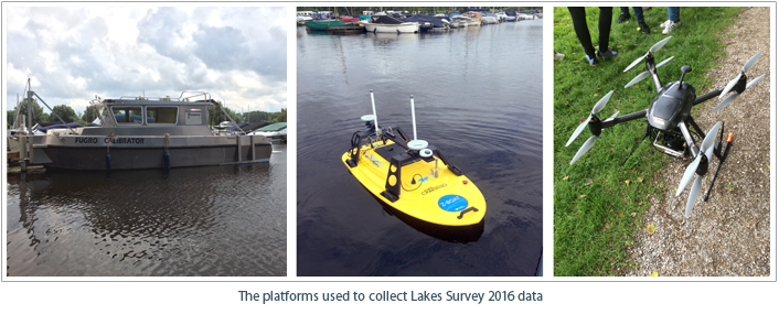
Twenty 3rd year students of Ocean Technology from the Maritime Institute Willem Barentsz (MIWB) participated in the 4th edition of the Lake Survey. Building on last years’ experience and together with three new partners, Teledyne CARIS™ and Fugro were able to enhance the program. A Survey Motor Boat (SMB), an Unmanned Surface Vehicle (USV), and Unmanned Aerial Vehicle (UAV) were used to acquire elevation data on and around the Vlietland lake in Leidschendam, the Netherlands.
 Since 2013, Teledyne CARIS has organized an annual practical survey for Ocean Technology students from the MIWB. The goal of the Lake Survey is to expand the experience of the young surveyors in a controlled environment. Sand excavation pits in the Netherlands have been the ideal theatre for this purpose. The lakes can be surveyed completely within the limited time frame and the nature of the lake bathymetry makes for interesting bottom landscapes.
Equipment
The Fugro Calibrator equipped with a Teledyne RESON Seabat T50-P multibeam covered the deeper areas of the lake. A Teledyne Oceanscience Z-boat with an MB2 multibeam, running CARIS Onboard, surveyed the shallowest areas and Skeye BV flew an Altura Zenith ATX8 drone with a 36 Megapixel camera over a part of the lake's shore.
In the Field
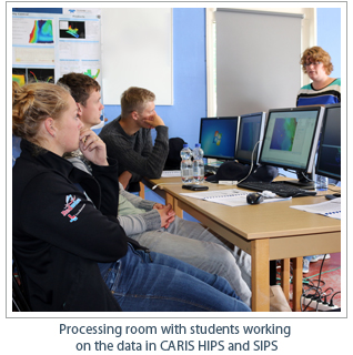
The Fugro Calibrator sailed from the Vlietland marina. The pole-mount made it a suitable platform to be equipped with any available sensor. Teledyne RESON had offered to supply their latest multibeam sonar for this project. Using a flange and network interfacing the T50-P was installed on the SMB. A RESON engineer supported the installation and from Fugro, a boat driver and surveyor supervised the students as they executed the survey. The students went through calibration before starting the survey lines. Besides bathymetry, backscatter data was also logged. Water column data was collected over bottom objects and on an air hose that is present to improve the lake's water quality. All data was processed in CARIS HIPS and SIPS™ by the students themselves.
 The Z-boat was sent by Teledyne Oceanscience. It was fitted with an Odom MB2 multibeam system. Operating in shallow and inaccessible parts of the lake, an engineer from Oceanscience and Teledyne CARIS supervised the students while surveying with this unmanned platform. After an introduction to the system and its components, the students steered the boat manually with the remote control. Alternatively, the Z-boat was put into autonomous mode and sailed a defined line-plan. This USV was running CARIS Onboard™, a near real-time data processor. Over the system's radio link, a processed DEM gave insight into the sonar performance and data quality. Reduced depths, TPU, and coverage results were used to monitor and update the survey plan. The processed data from the Z-boat was merged with the data from the Fugro Calibrator into a full coverage dataset.
In the Classroom
With a broad representation of the industry, the students learned the details of the latest evolutions in surveying. Teledyne RESON, Teledyne Oceanscience, Skeye BV, Fugro, and Teledyne CARIS all cooperated in this project, allowing students to gain practical experience in the field by utilizing some of the newest pieces of hardware and software. Representatives from the companies organized lectures where the students were taught the theory behind the hardware as well.
With a long career ahead, the students have a better understanding of their future work, the systems and software to be used, and met potential international colleagues and like-minded people to work with. During the week, the students camped together with representatives from Teledyne and Fugro. With one more year of studying, these bright-minded young surveyors will soon be ready for their jobs around the world.
Results and Dataset
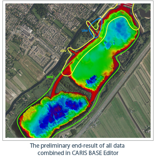
All collected data is combined into one dataset and will be available for download with a free viewer from www.caris.com/. Separate layers are created for the different sensors and data types. DEM, Mosaic and Point cloud layers can be viewed in 2D and 3D together with background and vector product files. For more information, contact info@caris.nl
Join our Mailing List
Subscribe to email announcementsOur Latest Tweets
Tweets by Teledyne CARIS Follow us on TwitterConnect With Us
