News
Reducing the Ping-to-Chart™ time with Unmanned Systems and CARIS Onboard
During the Meso American-Caribbean Sea Hydrographic Commission (MACHC) meeting, which was held in December 2015 in Antigua, staff from CARIS demonstrated the capability of conducting an unmanned hydrographic survey, processing the data and generating a nautical chart within 24 hours.
A Teledyne Oceanscience Z-Boat was equipped with a MB1 multibeam echo sounder and ancillary sensors to work as a fully integrated hydrographic survey platform. Sent as a complete package, the vessel was set up before the survey, packed into a single crate and shipped to the survey area as a turn-key vessel. Operated from the shore, the vessel was controlled by a radio link to an operator who could access the onboard computer through a long range Wi-Fi link.
The Z-Boat was deployed in the turquoise waters of Jolly Harbour, a location within walking distance of the MACHC meeting within Antigua. The vessel was then used to survey the harbour and the dredged channel around the approaches to the harbour to confirm the charted depths in the area.
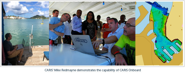 Whilst the survey was taking place, the data was concurrently being processed onboard the Z-Boat using CARIS Onboard software. This took a data processing workflow that was defined by the surveyor before the start of the work, which was used by the software to convert, clean and correct the multibeam data at the end of each survey line. As this was occurring on the platform at the time of the survey, it allowed the surveyor to see the bathymetry and the data quality in near real time. In addition, when the vessel was recovered, the dataset was simply downloaded and viewed immediately in HIPS and SIPS software.
Once the platform was recovered and the data downloaded, the previously generated multibeam surface was converted into an ASCII text file and sent via email to CARIS staff in the USA. Using CARIS BASE Editor and Paper Chart Composer, soundings were generated from the source data and plotted onto the existing nautical chart for the area. In total the survey gathered over 500,000 multibeam soundings over the period of seven hours, and the total time from the first ping to the production of the chart was less than 24 hours.
The demonstration showed how using a combination of unmanned survey platforms and autonomous onboard data processing can significantly reduce the time taken from starting a survey to generating a final product.
Join our Mailing List
Subscribe to email announcementsOur Latest Tweets
Tweets by Teledyne CARIS Follow us on TwitterConnect With Us
