News
USGS publishes new topobathymetric data powered by Teledyne Geospatial CZMIL SuperNova lidar system
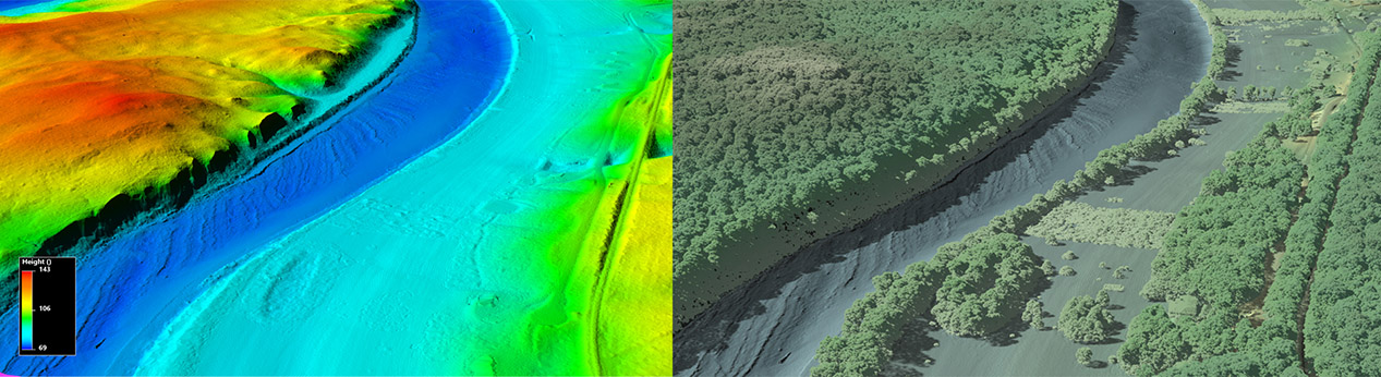
Vaughan, Ontario, CANADA – December 12, 2023 – Teledyne Geospatial congratulates the U.S. Geological Survey (USGS) and Dewberry, a privately held professional services firm, on the publication of a new topobathymetric lidar dataset for the Potomac River. The Potomac River flows from the Potomac Highlands in West Virginia to the Chesapeake Bay in Maryland. The lidar survey was conducted for USGS’s 3D Elevation Program (3DEP), with stakeholders including the USGS Earth Resources Observation and Science Center (EROS), National Geospatial Program (NGP), and Eastern Ecological Science Center (EESC) programs, as well as the Interstate Commission on the Potomac River (ICPRB).
Using their Teledyne Optech CZMIL SuperNova lidar system Dewberry surveyed 55 miles of the Potomac River from Hancock, MD down to Shepherdstown, WV, acquiring a total of 12.5 square miles of submerged topobathymetric lidar data. The project deliverables included a 3D point cloud and seamless topobathymetric Digital Elevation Models (DEMs) for that section of the river.
This was the 2nd Potomac River project, with the first extending from Shepherdstown, WV to the Little Falls dam near Washington, D.C. It is expected that these maps will provide a much-needed tool to predict the presence and movement of oil spills in the Potomac River and support ICPRB’s mission to protect and enhance the waters and related resources of the Potomac River basin through science, regional cooperation, and education.
“Given the depths, water conditions, and bottom substrate of the Potomac River, we were hopeful we’d get bottom returns with the enhanced CZMIL SuperNova system and couldn’t have been happier with the level of complete, seamless coverage achieved,” said Emily Klipp, Dewberry senior associate and senior project manager.
The project required an aggregate nominal point density (ANPD) of 1.5 points/m2 in shallow water (~1.5x secchi depth). The survey was able to exceed this specification and deliver 6.25 points/m2. The topographic portion of this dataset was tested to meet ASPRS Positional Accuracy Standards for Digital Geospatial Data (2014) for a 10 cm RMSEz Vertical Accuracy Class. Actual non-vegetated vertical accuracy was found to be 8.8 cm (RMSEz). The bathymetric vertical accuracy was found to be 6.1 cm (RMSEz), equating to ± 12.0 cm at 95% confidence level.
“I am very pleased to see the CZMIL SuperNova take on another challenging riverine environment mapping its banks and bed with such high detail. Congratulations to Dewberry for this great success in topo-bathymetric data production!” commented Malek Singer, Airborne Product Manager, Teledyne Geospatial.
Teledyne Geospatial unifies the lidar technology and software expertise of both Teledyne Optech and Teledyne CARIS. The new group provides customers with innovative integrated solutions. Offerings include turnkey systems and OEM products, lidar and sonar integrated workflows and a range of systems and solutions that support holistic, precision data collection.
Dewberry is a leading, market-facing firm with a proven history of providing professional services to a wide variety of public- and private-sector clients. Recognized for combining unsurpassed commitment to client service with deep subject matter expertise, Dewberry is dedicated to solving clients’ most complex challenges and transforming their communities. Established in 1956, Dewberry is headquartered in Fairfax, Virginia, with more than 50 locations and 2,000+ professionals nationwide. To learn more, visit www.dewberry.com.
For media enquiries, please contact:
Jennifer Parham
Jennifer.Parham@teledyne.com
Join our Mailing List
Subscribe to email announcementsOur Latest Tweets
Tweets by Teledyne CARIS Follow us on TwitterConnect With Us
